One of Iceland’s many volcanoes began erupting on March 19. The eruption caught a swarm of media attention, and attracted crowds of tourists who hiked to watch lava rivers ooze from the volcano.
The small island country of Iceland is filled with multiple volcanoes that litter its entire landscape. About 130 volcanoes in total are on the island, and about 30 active volcanic systems lie beneath the island. It is considered one of the countries with the most volcanoes on the planet coming in fourth place, just under Indonesia which has 139 volcanoes, and just above Japan which has 112.
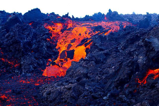
The volcano that began erupting in southern Iceland is the Geldingadalur volcano. It is located in the southwest region of the country, about 15 to 20 miles outside of the country’s capital of Reykjavik.
According to the Reykjavik Tourism website, the Geldingadalur volcano has been dormant and has not erupted in about 800 years. Geldingadalur, a shield volcano, is part of the Krysuvik volcanic system.
Shield volcanoes are known for their fluid lava that runs off of them, and many of the largest volcanoes on the planet are shield volcanoes. The Hawaiian shield volcanoes are among the most famous, with Kilauea and Mauna Loa being the two most famous ones in the state.
In the weeks leading up to the volcano’s eruption, there were a multitude of earthquakes in the region; more than 50,000 were recorded. This is the largest number of earthquakes that have been recorded since the digital recording of earthquakes in the region began in 1991.
27 of the earthquakes recorded near the site of the volcano were a magnitude of 4.0 or more.
Icelanders had been preparing for an eruption for weeks after experiencing the mass of earthquakes they received, according to the BBC.
According to experts, the eruption is small, controlled and does not pose a great threat. More than 10.5 million cubic feet of lava have poured out from the eruption.
NASA and NOAA satellites were both able to capture images of the eruption from space. The image captured by the satellites shows the site of the eruption as another bright spot just south of Reykjavik.
Tourists who were willing to make the 2.2 mile hike traveled to see the lava flows that were coming from the volcano. According to the BBC, scientists were filmed at the foot of the volcano cooking sausages on the somewhat cooled lava as they studied it.
The site of the volcano was blocked off initially, but on March 20, people were allowed to visit the site. As of Monday, March 22, the area was closed off again due to high levels of gas pollution coming from the volcano.
While scientists were cooking sausages, there were some individuals who were seen in a video on social media playing volleyball near some lava flows. Other tourists have flown drones over the site to capture images of the eruption and lava flows coming from the volcano.
Tourism websites have even taken the opportunity to recommend the best days to go hiking to see the volcano. Their recommendation is to go on days when the winds are blowing from the south, so it pushes toxic volcanic gases to the north.